Latest News Articles

Everyone can read the (free) Standard Edition articles. However,  the Plus Edition articles are accessible only to (paid) Plus Edition subscribers. 

Read the (+) Plus Edition articles (a Plus Edition username and password is required).

Please limit your comments about the information in the article. If you would like to start a new message, perhaps about a different topic, you are invited to use the Discussion Forum for that purpose.

Do you have comments, questions, corrections or additional information to any of these articles? Before posting your words, you must first sign up for a (FREE) Standard Edition subscription or a (paid) Plus Edition subscription at: https://eogn.com/page-18077.

If you do not see a Plus Sign that is labeled "Add comment," you will need to upgrade to either a (FREE) Standard Edition or a (paid) Plus Edition subscription at: https://eogn.com/page-18077.

Click here to upgrade to a Plus Edition subscription.

Click here to find the Latest Plus Edition articles(A Plus Edition user name and password is required to view these Plus Edition articles.)

Do you have an RSS newsreader? You may prefer to use this newsletter's RSS feed at: https://www.eogn.com/page-18080/rss and then you will need to copy-and-paste that address into your favorite RSS newsreader.

Want to receive daily email messages containing the recently-added article links, complete with “clickable addresses” that take you directly to the article(s) of interest?

Best of all, this service is available FREE of charge. (The email messages do contain advertising.) If you later change your mind, you can unsubscribe within seconds at any time. As always, YOU remain in charge of what is sent to your email inbox. 

Information may be found at: https://eogn.com/page-18080/13338441 with further details available at: https://eogn.com/page-18080/13344724.


Latest Standard Edition Articles

  • 16 Apr 2024 8:49 AM | Anonymous

    The following is a press release issued by the (U.S.) National Archives and Records Administration:

    Archivist of the United States Dr. Colleen Shogan is pleased to announce that Dr. Pearl Ponce will serve as the Director of the George W. Bush Presidential Library in Dallas, Texas, effective June 2, 2024. Dr. Ponce will lead the planning, directing, and administration of all Library programming and activities.

    I am excited Dr. Ponce is joining the National Archives team. With her deep knowledge of the presidency and foreign relations, and her passion for American democracy, she will be an excellent steward for the George W. Bush Library and a strong voice for archival research and public engagement,” said Shogan. “The Presidential libraries provide an important framework to better understand the complexities of our democracy and the decisions that shape our nation.”

    refer to caption

    Enlarge

    Photo courtesy of Dr. Pearl Ponce

    Dr. Pearl T. Ponce has a long and distinguished academic career. As a professor at Ithaca College, she served as chair of the history department for six years. During this time, she  operated in a leadership role overseeing curricular revision; accreditation and program reviews; and mentoring peers, colleagues, and students at the college and beyond. Dr. Ponce is a political and diplomatic historian with a specialty in the Civil War era, having taught a wide range of courses in United States history, such as the American Civil War and Reconstruction, The House Divided: The United States in the Long 19th Century, 1800-1914, and the History of United States Foreign Relations.

    She is the author of "To Govern the Devil in Hell: The Political Crisis in Territorial Kansas” and the editor of “Kansas's War: The Civil War in Documents.” Her main research interests have centered around the presidency, governance and democracy, the exercise of federal power, and the territorial system. Her latest project, "’A Strange System of Terrorism’: Federal Power and the Fraying of Democracy in Utah, Washington, and Kansas Territories in the 1850s,” brings these threads together. 

    She earned a master of arts and doctorate in history from Harvard University, a master of arts in history and certificate in contemporary history from Ohio University, and a bachelor of arts in international relations from Pomona College. 

    "The George W. Bush Foundation is thrilled to welcome Dr. Pearl Ponce as Director of the Bush Library in Dallas," said Ken Hersh, president and CEO of the Bush Foundation. "Her tremendous academic credentials and scholarship on the presidency will make her a great asset for historians, researchers, and educators. The presidential archives at the Bush Library are a national treasure, and I know she will steward them well."

    The George W. Bush Presidential Library is one of 15 libraries in the Presidential Library system operated by the National Archives and Records Administration, representing Herbert Hoover through Donald J. Trump. Presidential Libraries and Museums are repositories for each administration's papers and records and preserve and provide access to historical materials, support research, and create interactive programs and exhibits that educate and inspire.

  • 15 Apr 2024 9:24 AM | Anonymous

    The following is a press release issued by the (U.S.) National Archives and Records Administration:

    A new state-of-the-art digitization center at the National Archives and Records Administration (NARA) in College Park, Maryland, is allowing the agency to provide greater public access to the country’s most important historical federal government records faster than ever before. Maryland Senator Chris Van Hollen, Representative Steny Hoyer, and Representative Glenn Ivey joined Archivist of the United States Dr. Colleen Shogan today for a ribbon-cutting ceremony to formally celebrate the center’s launch.

    The new center’s equipment fleet includes high-speed scanners and overhead camera systems that can handle a variety of record types and formats. Thanks to this equipment, the National Archives will be able to digitize up to 10 times as many records per year. This will provide Americans with access to millions of additional records each year. With more than 13 billion paper records in its holdings, being able to speed up digitization is critical to the agency’s mission of providing access to federal records.

    refer to caption

    Enlarge

    From left; Representative Steny Hoyer, Archivist of the United States Dr. Colleen Shogan, Senator Chris Van Hollen, and Representative Glenn Ivey cut the ribbon at a ceremony to celebrate the launch of the new digitization center at Archives II in College Park, Maryland, today.

    “With new high-speed scanners and a dedicated team of digitization staff, this new Center is a game changer for the National Archives,” Shogan said. “It provides us a ten-fold increase in our in-house scanning capacity and will help us make millions of original records accessible online for Americans everywhere."

    “Our mission at the National Archives is to preserve, protect, and share our nation’s records,” she added. “And this will actually help us achieve all three of those goals.”

    Senator Van Hollen underscored the importance of digitizing records to provide access for future generations of Americans. 

    “Preserving—and learning from—our history plays a key role in our democracy. NARA is critical in this effort—archiving our nation’s treasured documents to ensure they’re accessible for generations to come. That’s why I worked to secure funding to support NARA’s new digitization center. Through this center and their expanded digitization efforts, Americans will be able to quickly and conveniently gain online access to more of the deep history that NARA holds.” 

    Representative Hoyer, who was instrumental in getting funding for the construction of the National Archives at College Park, which opened in 1994 and is home to the new digitization center, spoke during the ceremony.

    “This is the best archival institution in the world,” said Hoyer. “It is the best, most stable archival institution in the entire world. It is the largest and also one of the best. And this digitization capacity will make it even better.”

    Representative Ivey spoke to National Archives employees gathered for the ceremony. He shared his own story of researching his family history as an example of the impact of their work  on millions of people around the world. 

    "The record is there… It's critical that people like you and an institution like this are making sure we track that [U.S.] history because this is a history that's going to make a difference. It already does. It inspires people around the world,” said Ivey. “So thank you for the work that you do. Keep it going, keep it up."

    Employees began working in the 18,000-square-foot center when renovation of the space was completed in October 2023. The center’s opening is the first phase of a multiyear renovation project to support the mass digitization of enormous volumes of textual, photographic, and microfilm archival records and allow the agency to better meet its goal of providing access to its holdings digitally online

    “By far, the biggest change in our digitization capacity is the addition of three high-speed conveyor belt scanners that will enable the National Archives to safely scan fully prepared archival materials on a much larger scale than we have been able to do in the past,” Digitization Division Director Denise Henderson said. “As part of our digitization strategy, we are developing our in-house digitization expertise and expanding our digitization capabilities. The digitization center is expected to digitize thousands of cubic feet per year, producing millions of new digital images per year of archival records that are currently only available for viewing in person at National Archives facilities.”

    The digitization center is tasked with priority digitization projects and supporting partner and donor projects. Current projects include the Alaska Digitization Project, which covers a wide range of records relating to Alaska; the John F. Kennedy Assassination Records Collection; and the City Survey Files, textual records associated with the racially discriminatory practice of redlining maps. 

    Staff also digitize accessioned microfilm and microfilm publications in the digitization center, like the more than 41,000 microfilm rolls of the 1960 Census. Initial work has begun on that collection and will be accelerating in preparation for the 2032 release.
    The next phase of the evolution of the digitization center is already underway and will include constructing new, modern labs for digitizing motion picture and audio-visual archival records. This phase is expected to be completed by September 2024. 

    Future plans for the center include additional records storage space and cold storage space for the agency’s most fragile records.

    The National Archives will continue to post new digital images to the online National Archives Catalog, where they will be available to the public for free viewing from any location. The latest additions are regularly updated on What’s New in the Catalog on the National Archives website. The Catalog currently offers more than 270 million digital records. 

    “We are committed to expanding free, online public access to our holdings through the National Archives Catalog,” Shogan said. “This new digitization center will help us meet our strategic goal to digitize and make available 500 million pages of records by September 30, 2026, and even larger numbers after that.”

  • 15 Apr 2024 9:20 AM | Anonymous

    Historically, African Americans have faced significant challenges with discovering their ancestral history due to lost or difficult to find genealogical records. Now, the Center for Family History (CFH) at the International African American Museum (IAAM) is helping to bridge that gap. Recently the CFH launched its new Genealogy Research Area and Reference Library. These resources give visitors access to millions of online genealogical records, including more than 1,300 books, and offers them the benefit of real-time expertise from onsite CFH genealogy experts.

    “Conventional wisdom has been that African Americans cannot trace their ancestry in the U.S., prior to 1870,” said CFH Director Brian Sheffey. “With the addition of these resources to the Center for Family History, the museum is making significant strides to change that misperception.”

    The tech forward CFH Research Area features iPad stations where visitors can search 32 popular genealogy and African American historical websites to begin or further the journey of uncovering their family history.

    Visitors are asked to bring a USB-C or a standard USB flash drive to save generated genealogy documents to help maintain the center’s paperless environment.

    Nearby, the CFH Reference Library is home to over 1,300 books covering a wide range of genealogy topics. Books reservations are available online at www.libib.com/u/iaamcfh for registered library patrons only. To become a patron of the Research Library, visitors must email their interest to cfh@iaamuseum.org along with their first and last name.

    The CFH offers free digital resources on family genealogy. Those seeking additional guidance on uncovering the history of their ancestry can register for a virtual one-on-one consultation. The cost is $79 for a 45-minute session. Consultations are offered Monday–Friday from 10 a.m.-3 p.m. Reservations can be made online.

    You can read more in an article published in the postandcourier.com web site at: bit.ly/3W0zA50

  • 12 Apr 2024 4:23 PM | Anonymous

    The following is a Plus Edition article written by and copyright by Dick Eastman. 

    NOTE: This article describes a technical solution to the problem of being blocked from accessing videos of interest being broadcast on web servers in foreign countries.

    In recent months, a number of genealogy television programs that sound interesting have become available on the Web in England and in the U.S. Specifically, episodes of the U.K. version of Who Do You Think You Are? are available online. Many of us in North America, Australia, New Zealand, and elsewhere would love to watch these programs, but access is blocked by the networks. The U.K. networks do not have licensing rights for other countries, so the web sites block access by any non-U.K. viewers.

    Of course, it is a two-way street. Episodes of the U.S. versions of many programs also block users from other countries from viewing the programs. Netflix is probably the best-known video service that blocks foreign viewers but there are many more examples. Many viewers in Canada and overseas would like to watch these programs online but, again, are blocked for the same reason. The "problem" isn't limited to genealogy or even to videos. Some contries block access to all sorts of web sites. China is an excellent example of a country that blocks access to foreign web sites but others include the repressive countries of Russia, Iran, Egypt, Saudi Arabia, Libya, and many more. 

    Isn't this supposed to be the WORLD WIDE Web? Not according to the folks who write contracts!

    Luckily, there is an easy workaround for all this. I recently watched a supposedly-restricted program from the BBC on my laptop computer, even though I was at home in the United States at the time. A lot of other users around the world are watching videos and listening to music that supposedly aren't available in their home countries. This week I'll tell Plus Edition subscribers how to do the same.

    The remainder of this article is reserved for Plus Edition subscribers only. If you have a Plus Edition subscription, you may read the full article at: https://eogn.com/(*)-Plus-Edition-News-Articles/13342683 (A Plus Edition password is required to access that article.)

    If you are not yet a Plus Edition subscriber, you can learn more about such subscriptions and even upgrade to a Plus Edition subscription immediately at https://eogn.com/page-18077
  • 12 Apr 2024 4:05 PM | Anonymous

    In the Czech Republic, there are many fascinating and historically significant cultural monuments. Many are proudly listed as UNESCO World Heritage Sites, such as Prague Castle and the Charles Bridge. Not far from these world-famous monuments lies another one, a unique jewel: the Baroque Library inside Prague’s Clementinum, which houses the vast and valuable collections of the National Library.

    Today, on the occasion of the 100th anniversary of the Slavonic Library, which is part of the National Library, I’m honored to announce a partnership between our institution and Google Arts & Culture. This collaboration is a harmonious fusion of cultural heritage and modern technology. Thanks to modern imaging methods and virtual tours in Street View, everyone will be able to visit the unique Baroque spaces of one of the most beautiful libraries in the world at any time, no matter where they are.

    They can also view over 200 exceptional historical documents displayed on this occasion from the National Library's collections, four digital stories and a Czech National Library puzzle party for creative souls. The virtual experience on Google Arts & Culture also includes the exploration of significant historical manuscripts that are usually not available to the public, such as the Vyšehrad Codex — one of the most valuable manuscripts preserved in the Czech Republic — and digitized treasures like Caspar Pflieger's Star Globe and Sebastian Münster's Map of the New World.

    Working with Google is nothing new for us. Nearly 200,000 old prints have already been digitized by Google in previous years. I am delighted that by working with Google Arts & Culture we can breathe new life into the Library's collections and make them available to the general public around the world in a stunning virtual presentation.

    You can read more in an article by Tomáš Foltýn, Director of the National Library of the Czech Republic, at: http://bit.ly/3Qo090r.

  • 12 Apr 2024 8:36 AM | Anonymous

    The following announcement was written by the folks at Findmypast:

    From wartime to workhouse records, there are 180,000 Warwickshire additions to explore this week. 

    This week we added 183,015 new records from the county of Warwickshire. Delve into Second World War history in more detail than ever with new Coventry bomb damage schedules and updates to our existing Coventry Air Raid set. 

    There are also new Coventry workhouse registers and burials to explore. From the West Midlands to Toronto, enrich your family tree with new newspaper pages that span the globe. 

    Coventry Bomb Damage Schedules 1940-1941 and Coventry Blitz, German Air Raids 1940-1941

    These 74,615 new and updated records recount the German Air Raid bomb damage that Coventry suffered between 1940 and 1941.

    Taylor (Lt) - War Office official photographer

    Broadgate in Coventry city centre following the Coventry Blitz of 14/15 November 1940 

    Warwickshire, Coventry, Bomb Damage Schedules is a brand new set, comprising 73,811 images and transcriptions which cover the years 1940 and 1941.

    To further bolster our Blitz record collection, we've also added 804 new transcriptions and images to our existing Warwickshire, Coventry Blitz, German Air Raids 1940-1941 record set. 

    If your ancestor lived through this fateful period of British history in the county of Warwickshire, you may be able to glean key information about their experiences from these new and updated records.

    Coventry Workhouse Admission and Discharge Registers, 1853-1946

    If your ancestor passed through the doors of one of Coventry's workhouses between 1853 and 1946, their name may appear in this new brand collection. 

    There are 70,437 fascinating new workhouse additions for you to discover this Findmypast Friday. 

    Warwickshire Burials, 1847-1896

    We also added 37,963 burial records from Coventry's London Road Cemetery this week, covering the years 1847 to 1896. 

    New pages from Coventry to Canada

    There are 91,584 brand-new pages for you to explore this Findmypast Friday, with 22 new and updated titles that span the globe. 

    The Coventry Graphic, 1911.

    The Coventry Graphic, 1911.

    New titles:

    • Bedworth Times, 1875-1876
    • Coventry Graphic, 1912-1921
    • Foleshill & Bedworth Express, 1874-1876
    • Gainsborough Evening News, 1954-1983, 1987, 1992-1994, 1996
    • Matlock Mercury, 1986-1988, 1990, 1992-1994, 1996, 1998, 2000
    • Piercy’s Coventry Gazette, 1778

    Updated titles: 

    • Arbroath Herald, 1964-1973
    • Coventry Standard, 1747-1748, 1751, 1755, 1757, 1759-1794, 1798-1811, 1814-1831
    • Derbyshire Times, 1986
    • Eastbourne Gazette, 1988
    • Edinburgh Evening News, 1995
    • Hartlepool Northern Daily Mail, 1982, 1985-1987
    • Leamington Spa Courier, 1984, 1987
    • Market Harborough Advertiser and Midland Mail, 1993, 1995-1996, 1998
    • Melton Mowbray Times and Vale of Belvoir Gazette, 1890-1893, 1999
    • Morpeth Herald, 1998-1999
    • Motherwell Times, 1983
    • Northamptonshire Evening Telegraph, 1955-1956, 1987-1988, 1990-1991, 1993-1995, 1997-1998, 2001
    • Rugby Advertiser, 1855, 1960-1968, 1984
    • Stornoway Gazette and West Coast Advertiser, 1967-1971, 1975-1985, 1988
    • Toronto Daily Mail, 1881
    • West Sussex County Times, 1983, 1986-1987

    We added 100,000 brand-new record sets last week. Don't miss out - discover the full release here.

    Have you made a surprising family history discovery? Whatever you've uncovered about your past, we'd love to hear about it. You can now get in touch and tell us using this handy form.

  • 12 Apr 2024 8:19 AM | Anonymous

    The following is a press release written by the folks at the Australian National University:

    The first database of message sticks used in Indigenous Australia has been created, pulling together records and information on message sticks housed in museums and archives around the world. Message sticks are wooden objects used by First Nations Australians for communicating over long distances. The database contains images and any available information about origin and meaning for over 1,500 individual message sticks. Uniquely, the database is informed by the Indigenous Australian concept of Country and deliberately prioritises Indigenous knowledge. The authors say that, for the first time, knowledge about Australian message sticks can be evaluated as a single set, and they hope that the database will help Traditional Owners to identify and reconnect with ancestral knowledge.

    Journal/conference: PLOS ONE

    Link to research (DOI): 10.1371/journal.pone.0299712

    Organisation/s: The University of New England, The Australian National University

  • 12 Apr 2024 8:07 AM | Anonymous

    The following is a press release from TheGenealogist:

    We have all delved into our family history yearning to understand the lives of our ancestors, but after we have found them in the births, marriages and death records we will often turn to the census records to discover where they lived. But what happens if you've hit a brick wall in your research, struggling to piece together the puzzle of their past because they were, somehow, not at home on census night? What resource can we turn to as a substitute?

    It may be that we have found our ancestor in their home and discovered that their occupation reveals that they were a shopkeeper or small business person. What we would now like to know is where they ran their business from and discover more about the village, town or area of the city in which they worked.

    The latest release from TheGenealogist contains over 10 million new individuals recorded in directories from the first two decades of the 20th Century. This virtual bookshelf stacked with volumes from the early 1900s to 1929 includes publications from all over the United Kingdom and Ireland.

    These directories are filled with listings of people, their addresses and details of the places they lived in. Other directories list businesses and offer a fascinating glimpse into ancestors from this time. 

    Harris & Co can be found in the Hampshire directories on TheGenealogist

    You can use these records to discover the street address of your great-grandfather or their shop/business, perhaps learn where your great-grandmother practised her dressmaking trade from, or find the names of your ancestors' neighbours in the street listings. These directories will also reveal any listings of official positions that they may have held in charities, societies, local administration, etc., or even unearth your ancestor's telephone number!

    With some books you can read topographical details about the village, town or city in which your ancestor lived. This will give you a better feel for what their area was like at the time that your forebears lived there.

    Better than 50% off!

    To celebrate this latest release, TheGenealogist is offering its 12 months Diamond Package for just £98.95 – that’s over 50% off!

    To find out more and claim the offer, visit: https://www.thegenealogist.co.uk/MGBDIR424

    Expires on 12th May 2024.

    This offer includes a lifetime discount! Your subscription will renew at the same discounted price every year you stay with us.

    This includes the following:-
    Subscription to Discover Your Ancestors Online Magazine (Worth £24.99)
    Discover Your Ancestors' Occupations by Laura Berry (Worth £9.95)
    Researching and Locating Your Ancestors by Celia Heritage (Worth £9.95)
    Regional Research Guidebook by Andrew Chapman (Worth £9.95)
    Discover Your Ancestors Periodical Compendium Volume 1 (Worth £9.95)

    Total Savings: £105.79

    Read TheGenealogist’s article, More than just an address:

    https://www.thegenealogist.co.uk/featuredarticles/2024/more-than-just-an-address-7346/

    About TheGenealogist

    TheGenealogist is an award-winning online family history website, which puts a wealth of information at the fingertips of family historians. Their approach is to bring hard to use physical records to life online with easy to use interfaces such as their Tithe and newly released Lloyd George Domesday collections. 

    TheGenealogist’s innovative SmartSearch technology links records together to help you find your ancestors more easily. TheGenealogist is one of the leading providers of online family history records. Along with the standard Birth, Marriage, Death and Census records, they also have significant collections of Parish and Nonconformist records, PCC Will Records, Irish Records, Military records, Occupations and Newspaper record collections amongst many others.

    TheGenealogist uses the latest technology to help you bring your family history to life. Use TheGenealogist to find your ancestors today!

  • 11 Apr 2024 3:07 PM | Anonymous

    In Part #1 of this article (available at https://eogn.com/page-18080/13341291), I described how to find the longitude and latitude of almost any cemetery in the US. Now that you have identified the geographic coordinates, how do you travel to the site? Driving to that location may involve a few challenges. Of course, you can always plot those coordinates on a good map of the area and then use the map to find the cemetery. However, with the use of a high-tech device, you can easily obtain real-time instructions on how to drive directly to the cemetery. In many cases, a robotic voice will even tell you when to turn left or right along the route.

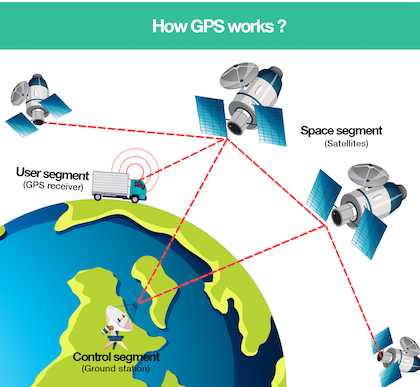
    The technology that makes this possible is the Global Positioning System (GPS). The GPS consists of a constellation of 24 active satellites (and one or more in-orbit spares) orbiting the earth every 12 hours. Four satellites are located in each of six orbits. The orbits are distributed evenly around the earth and are inclined 55 degrees from the equator. The satellites orbit at an altitude of about 11,000 nautical miles. These satellites broadcast time information that is accurate to a few microseconds (millionths of a second). Receivers on the ground can decode these time signals, apply some mathematics, and thereby determine the exact location of the ground receiver, plus or minus thirty feet or less.

    The Global Positioning System was first used by the military some years ago and soon after was adopted by the airlines. Using this technology, airline pilots and military personnel can determine their exact location at any time.

    The early GPS receivers had a price tag of tens of thousands of dollars. However, as the technology matured, prices dropped. About thirty years ago, GPS receivers fell into a price range that became attractive to fishermen, hunters, backpackers, RV owners, and long-haul truckers. In fact, recently I have seen simple GPS receivers on sale at the local Wal-Mart store for $74.88. However, most GPS receivers typically range from $129 to $499 for consumer models. You may even find GPS navigation units built into automobile dashboards, although usually at prices well in excess of $1,000.

    Today, all iPhones and most Android “smartphones” also contain GPS receivers. With the addition of a free or low-cost app, these phones also can be used as very accurate GPS devices. Several such apps are available for both iPhones and Android phones.

    The thing that fascinates me is that the free smartphone apps are just as accurate as the $1,000 dedicated GPS receivers: all of them can determine your location within 30 feet or less. Paying higher prices does not result in better accuracy. It does, however, increase the number of features available. As you move up in price, you find GPS receivers with larger displays, and even self-updating databases. The high-end units made for automotive use will even talk to you, warning you of upcoming turns as each guides you to your destination.  Some of them allow you to talk back as they have voice actuated commands. The GPS in one of my automobiles even projects its display as a transparent image on the windshield, meaning the driver never needs to take his or her eyes off the road while navigating. This “head up display” greatly enhances safety. The same GPS device also uses voice input for all commands; I can specify new routes and search for locations all while keeping both hands on the steering wheel. All I need is my voice. 

    I have used a number of GPS receivers in recent years. Several of the low-cost GPS receivers plug into laptop computers, allowing you to use your existing laptop's power and storage capabilities to equal the performance of free-standing GPS units that cost thousands of dollars. 

    One free-standing handheld GPS unit I own is typical of today’s GPS products: it slips into a shirt pocket, weighs six ounces, operates on two penlight cells, and has a built-in map of all the major highways, lakes, rivers, railroad tracks, and other major features within the United States. It also has the capability of downloading detailed map information for a small area, including side streets and topographical mapping information. It has a "street price" of about $99. Best of all, for a few more dollars, a cable is available that allows the portable GPS to be connected to a laptop PC.

    Perhaps even more useful is a GPS app installed in a “smartphone.” My favorite is Waze, a free app that not only displays all the normal GPS information but also provides up-to-date information about traffic jams, highway construction, and even speed traps. Not bad for a free app that can be added to a cell phone you already own! This provides great technology at no increase in price over what you have already invested into your cell phone.

    If you wish to drive to a cemetery that may contain the grave of an ancestor, you can simply enter the latitude and longitude of the cemetery, as obtained from the GNIS database, into almost any modern GPS receiver, and it will point the way. With some programs, the laptop will even talk to you when it is time to turn left or right. The result is that you can keep your eyes on the road while you listen to navigation instructions.

    A few years ago I used a newly-purchased GPS to locate several small cemeteries in Epping, New Hampshire. I was looking for the grave of Daniel Dow, an ancestor who lived in Epping in the late 1700s and early 1800s. I know little about this man other than his name and the dates and locations of his birth, marriage, and death. I was hoping to find a few more details. I did not know where he was buried, but I did know that he spent his adult life in this small town. I assumed correctly that there would only be a few cemeteries in the town and that none of them would be very large. The fact that it was a warm spring day and I had a brand-new convertible sports car added to the enticement, of course.

    I first looked on the Geographic Names Information System’s Web site and printed out a list of all the cemeteries in Epping, New Hampshire. This list included latitudes and longitudes. I then jumped in my sports car, turned on the GPS receiver, and entered the same latitudes and longitudes into the GPS receiver (which can store up to 500 of these "waypoints"). Once that task was completed, I started the car and sped off. 

    I selected the first cemetery, or waypoint, and the GPS receiver pointed the way. When I say "pointed the way," that is exactly what it did. The GPS receiver has an arrow that points straight up if the desired destination is straight ahead. If the destination is to the left or right of your automobile, the GPS receiver’s arrow points in the appropriate direction. The receiver also has digital displays that show your speed, the distance remaining to the waypoint, and a lot of other information.

    The roads in Epping certainly are not all in a straight line. This is a typical rural New England village with winding back roads, many of them unpaved. I could not always follow in the exact direction that the arrow indicated, but I usually was able to go in the approximate direction. As I got closer and closer to the designated cemetery, the digital readout for "distance remaining" approached zero.

    I easily found several larger cemeteries, but all proved to have no evidence of my elusive ancestor. I punched in the coordinates for the final cemetery on the list and headed off, following the advice of the GPS arrow. I soon found myself on an unpaved road that led through dairy farming country. The "distance remaining" display kept counting down, one mile… one-half mile… five hundred feet… one hundred feet… fifty feet. I didn’t see a cemetery and continued driving. However, the "distance remaining" started counting back up again.

    I turned around at the next farmhouse and headed back. The "distance remaining" display repeated the earlier scenario. It counted down to thirty feet and then started counting up again, all with no cemetery in sight.

    I made another U-turn and started a third pass although at greatly reduced speed. I stayed in first gear as I watched the GPS display. Again, the digits counted down. I then found that the display never went to zero. Instead, it would count down to thirty feet and then start counting up again. I overshot the location, so I backed up until the display said "thirty feet" and then stopped. The arrow pointed 90 degrees to my left. I turned the engine off and looked around. There was no cemetery in sight.

    Being curious, I got out of the car and started walking to the left. I counted off thirty feet as I walked off the road and through the thick underbrush. At approximately thirty feet from my automobile, I stopped and looked around. Again, no cemetery was visible. However, I seemed to be standing on something substantial, even though it was covered with brush. I leaned down, pulled the brush away, and discovered that I was standing on a tombstone that had apparently fallen over many years ago and was now covered with New England’s finest thick brush.

    In the next few minutes of poking through the thick underbrush, I found five more horizontal tombstones. With a bit of work, I was able to read the lettering on each. Thanks to the Geographic Names Information System and my GPS receiver, I had located a cemetery that was invisible from the road only thirty feet away. I doubt if I would have ever found that cemetery, had I been given a less precise description of its location.

    By the way, I wish I could report some success in looking for Daniel Dow’s grave in Epping, New Hampshire. Unfortunately, there was no trace of him in the brush-covered cemetery that I discovered.

    GPS receivers have many uses besides genealogy. In addition to determining the exact location of a cemetery tombstone or an ancestor's homestead, you can navigate down strange roads, find residential addresses that would be elusive otherwise, and even find fast-food restaurants while on cross-country trips. You can find courthouses in major cities, ATM machines almost anywhere, and hospitals if you have a medical emergency. The GPS built into one of my automobiles will even find the nearest vegan restaurant, if I ask for that. Best of all, a GPS receiver is the ultimate salvation for the male ego: you never, ever have to ask for directions.

    I would suggest that a GPS receiver is an excellent tool, both for cemetery hunting and for non-genealogy purposes. If you have an interest in adding this high-tech marvel to your genealogy toolkit, I would recommend that you first spend some time on the Web learning about the capabilities of these fascinating devices. A few of my favorite GPS Web sites include: , http://www.magellangps.com, http://www.lowrance.com, and the explanatory article in Wikipedia at https://en.wikipedia.org/wiki/Global_Positioning_System. Any search engine probably can find a few hundred more Web sites dealing with GPS technology. 

    Probably the most sophisticated GPS navigation systems are the ones built into some of today's luxury automobiles. These in-dash solutions typically include databases of streets and highways as well as the locations of hospitals, ATM machines, restaurants, fast food outlets, and much more. However, most of them do not list cemetery locations. There is little to no standardization among the various automobile manufacturers; each is free to supply whatever GPS navigational units they wish. In-dash units typically do not have external interfaces that the consumer can use. Most are labeled with the car manufacturer's name although a different company typically supplies the technology. The in-dash units are usually quite expensive; prices often run from $1,000 to perhaps as high as $2,000. Even worse, when you trade the car, the GPS navigational system goes with the vehicle. 

    A much more cost-effective solution is to purchase a portable GPS receiver, often a handheld unit. Prices vary from $79 to $999 (U.S. funds). Surprisingly, the $79 units are as accurate as the $2,000 in-dash devices; both can determine your location, plus or minus thirty feet and sometimes even less than that. Many inexpensive GPS receivers work well on an automobile dashboard, attached with a piece of Velcro or perhaps a suction cup mount for the windshield that the manufacturer may include. I have used a variety of these units, all with good results.

    I also have a navigation system built into the dash of my current sports car. The built-in system looks better and is far more convenient to use than an external laptop and GPS receiver. However, many handheld GPS receivers provide the same functionality and accuracy as the expensive unit in the sports car's dashboard. 

    Perhaps the most useful GPS unit is the one built into most iPhones and Android cell phones. There are numerous GPS on the Android Play Store and iPhone App Sore. My favorite is Waze although you might prefer Google Maps or some other app. 

    There are a number of manufacturers of GPS receivers. The better-known manufacturers of consumer GPS receivers include Garmin, Magellan, Lowrance, and DeLorme. The GPS receivers vary widely in appearance and capability.  Almost all GPS receivers display latitude and longitude and have the capability for storing "waypoints" (locations along a planned route) that the user manually enters before embarking on a trip. In the past few years, built-in maps have become common. The maps typically show highways along with rivers, streams, oceans, and sometimes railroad tracks. However, trying to read the information on a small handheld device's display on a dark night while zooming down the expressway in heavy traffic is not recommended!

    Once the purchase price goes over $200, improvements multiply. Bigger map databases with more streets become common. When you go over $300, the screens get bigger and color displays become the norm. Almost al the larger units offer options for a selection for either the shortest or fastest routes, directions, and estimated arrival time to your intended destination. Automated voice prompts alert you to upcoming turns, course deviation, and distance to final destination. At the touch of a button, you can locate all the nearby highway exits, gas stations, restaurants, ATMs, hospitals, and rest areas, all on5-inch by 1.8-inch or even 7-inch full-color LCD display screens that can easily be read while in motion. 

    On longer trips you will need to be concerned about the laptop's battery life. You don't want the battery to fail while you are in the middle of unfamiliar territory! Most GPS receivers can be powered by the automobile's power socket. Again, you will need to buy a cable for this. 

    Safety becomes an important consideration when using a GPS receiver while in motion. The best method is to use two people: one drives while the other navigates. However, if properly planned and equipped, a solo driver can safely use GPS navigation units. Thousands of truck drivers do this daily, as do airplane pilots. Thousands of police officers also safely use their in-vehicle laptops every day. Some advance planning is necessary, however. Not only should you not text and drive, you also shouldn't be pressing the buttons or icons on a GPS receiver while in motion! (That's why I love my GPS receiver with voice input. I never take my two hands off the steering wheel or my eyes off the road.) 

    Placement of the GPS receiver is critical. Assuming a solo driver situation, you want to be able to view the device's screen without taking your eyes off the road. Having the GPS receiver in the passenger's seat or in the center console is not a good idea! For a handheld GPS receiver or cell phone, I use a small device that clips to the dashboard and securely holds the GPS receiver or cellphone in place at just below normal eye level. 

    All of this seems excessive for simply finding cemeteries. However, the price tag for adding Waze or another GPS app to your present cell phone is quite reasonable: FREE. Once you start using an in-vehicle GPS, you will find many uses for it. It is especially good for your next vacation trip. RV owners and long-haul truck drivers can testify to the usefulness of GPS systems. Many genealogists will do the same. 


Eastman's Online Genealogy Newsletter


Powered by Wild Apricot Membership Software